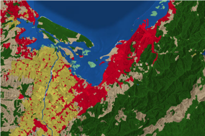
dynamic_world_dataset
谷歌发布了近实时的10-m分辨率的全球土地利用数据。这个数据是基于10-m分辩率的Sentinel-2影像。号称是可以用于任何最近获取的Sentinel-2影像上,实现近实时的土地利用分类。
参考来源:吴秋生 GISicence
本博客所有文章除特别声明外,均采用 CC BY-NC-SA 4.0 许可协议。转载请注明来源 星辰大海!
相关推荐
2022-08-22
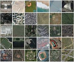
awesome-satellite-datasets
SEN12MSThe SEN12MS dataset contains 180,662 patch triplets of corresponding Sentinel-1 dual-pol SAR data, Sentinel-2 multi-spectral images, and MODIS-derived land cover maps. The patches are distributed across the land masses of the Earth and spread over all four meteorological seasons. This is reflected by the dataset structure. All patches are provided in the form of 16-bit GeoTiffs containing the following specific information: Sentinel-1 SAR: 2 channels corresponding to sigma nought...
2021-07-07
FY气象卫星
...
2021-07-20
landsat
Landsat 卫星波段设计 Landsat 1-5landsat 1-5 多光谱扫描仪包含 4 个通道,空间分辨率 60m,幅宽 南北方向 170km, 东西方向 185km。其中 Landsat 1-3 和 Landsat 4-5 波段设计不同,差异如下: landsat1, 1972.7.23 landsat2, 1975.1.22 landsat3, 1978.3.5 landsat4, 1982.3.1 landsat5, 1984.3.1 landsat6, 1993.10.5 landsat7, 1999.4.15 landsat8, 2013.2.11Landsat 1-5 Multispectral Scanner (MSS) Landsat 1-3 Landsat 4-5 波长(micrometer) 空间分辨率(meter) Band4 Band1 0.5 - 0.6 60 Band5 Band2 0.6 - 0.7 60 Band6 Band3 0.7 - 0.8 60 Band7 Band4 0.8 -...
2021-01-12
s5p
tropomi tools HARP software can be downloaded from GitHub: download HARP论坛 NO2 Mapping description, here MATLAB读取nc文件并转换为.tif格式(here), Matlab:Save as GeoTiff Format (here) Sentinel-5P数据的栅格化处理 (here) sp5 harp编写trans.sh,实现harp和gdal结合的批量nc-nc-tif conda install -c stcorp harp -y sudo apt install harp conda install gdal -y # harpconvert -a 'keep(latitude_bounds,longitude_bounds,tropospheric_NO2_column_number_density);bin_spatial(2400,-37,0.01,3300,-83,0.01);squash(time,...
2021-07-21
sentinel-1/2
哨兵2号哨兵 2 号共有 13 个波段,目前有 2 颗卫星,第一颗卫星 Sentinel 2A 2015年发射,第二颗 Sentinel 2B 2017年发射,后续 Sentinel 2C, Sentinel 2D 将于 2024年发射,这样将有 4 颗哨兵 2 号卫星,后续发射的卫星将提高一倍哨兵 2 号的重坊周期。 波段介绍哨兵二号装载多光谱成像仪,传感器共有 13 个波段,空间分辨率从 10m 到 60m 都有。 蓝(B2)、绿(B3)、红(B4)和近红外(B8)波段,空间分辨率为 10m 红边(B5)、近红外(B6, B7, B8A)、和短波红外(B11, B12),空间分辨率为 20m 海岸带/气溶胶(B1)、卷云波段(B10),空间分辨率 60m 波段组合 真彩色(4,3,2) 假彩色(8,4,3)If you want to see Sentinel band combinations for yourself, you can check out the Sentinel Playground. It visualizes the band...
2022-04-18
西沙xisha
自然资源部 民政部关于公布我国南海部分岛礁和海底地理实体标准名称的公告 ENVI5.3中吉林一号卫星图像数据处理 长光卫星下载中心 62325351 徐老师 OTSU阈值分割+孔洞填充+海陆分离, 吉林一号卫星宽幅01A星 高分02A星 高分03A星 worldview 可见光近红外利用遥感数据绘制的珊瑚礁特征和过程包括 ·p6: 珊瑚礁的覆盖范围 构成(底栖生物覆盖、栖息地特征等) 生物物理属性(水深、水质、海面温度等) 生物地球化学特征(初级生产物、钙化) 地质特征(地貌、沉积物多样性) 有关珊瑚礁遥感的研究沿着两个方向发展 p8: 针对水体和大气对遥感信号产生的影响,开发各种技术进行补偿 对珊瑚礁状态或功能更加深入展示的高级产品 岛屿名称 数据名称 问题备注 101_x永兴岛_x石岛 yongxing2005_0119,...